


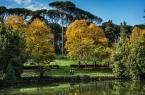


The reserve was instituted in 1997 and lies in south-west Rome between the Via Pontina and Via Laurentina, in the stretch outside the great ring road (the GRA), while the southern side borders on the municipality of Pomezia. The parklands of the nature reserve contain many archaeological remains including traces of Palaeolithic settlements. The area around Castel di Decima has a Bronze Age settlement and vast burial ground with tombs containing many artefacts. In ancient Roman times the area had many rustic villas with farming activities. During the Middle Ages most of the area was abandoned and many watchtowers (such as those of Decima and San Ferdinando) and castles were built. In later centuries many medieval structures were turned into farmsteads. The area is very rich in flora and fauna. The evergreen Mediterranean bush (in the lands bordering the estates of Castel Porziano and Castel Fusano), with holms, myrtles and cane-apples, gradually changes to mixed forests of turkey oaks, elms, cornels and hazels interspersed with alders and willows, and meadows with many herbaceous plant species. There is the occasional cork-oak as well. The many animal species found include the tortoise, newt, water snake, viper, hedgehog, mole, hare, porcupine, fox, badger, wild boar and fallow-deer.Notes: Protected area.
Information
Sempre aperto
 Condividi
Location
To find out about all accessibility services, visit the Rome accessible section.