


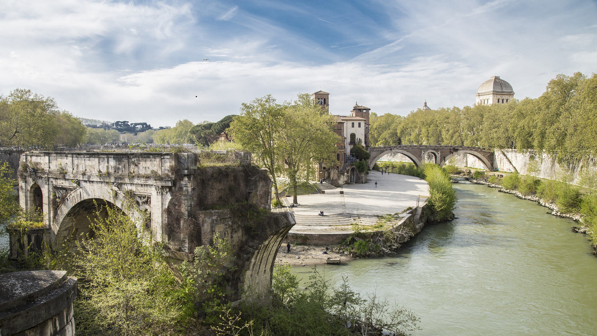
It is commonly known as Ponte Rotto (Broken Bridge) but the great arch with a decadent and poetic aspect that emerges from the waters of the Tiber, not far from the Tiber Island, is actually what remains of the ancient Pons Aemilius, made of wood in the 2nd century BC and reconstructed of stone a century later.
It was the longest of Rome’s ancient bridges with an important strategic position, but definitively not lucky: placed obliquely to the current of the river, where the water turbulence is particularly strong, it was very often overwhelmed by the power of the Tiber. Damaged when not destroyed, it was then reconstructed several times. Even its name often changed over the centuries: with the renovation carried out by Augustus, Emperor and Pontifex Maximus, it was nicknamed “Pons Maximus”, then in the 9th century it became known as the Santa Maria Bridge when the Temple of Portunus was turned into the church of Santa Maria Egiziaca. In 1144, the bridge was renamed Senatorium Bridge, probably following a full restoration carried out at the expense of the Senators, Rome’s main administrators.
Repairs and restorations also continued in the following centuries: the complete renovation of 1552, by Nanni di Baccio on a design by Michelangelo, proved to be ineffective and only five years later the bridge was again swept away by a flood. With the umpteenth reconstruction commissioned by Pope Gregory XIII Boncompagni in 1573 and remembered by a clearly legible inscription, as well as by the bas-reliefs with dragons that recall the papal coat of arms, the bridge was used to lead the new Acqua Felice pipeline to Trastevere, which fed the fountain in piazza di Santa Maria in Trastevere, but another violent flood on Christmas night in 1598 destroyed about half of the bridge, carrying away 3 arches and 2 piers. The remaining section of the bridge, anchored to the right bank, was used as a hanging garden until the end of the 17th century, when the precarious stability of the bridge made it completely unusable.
In 1853, the three remaining arches were connected to the mainland on both sides with an iron footbridge. In 1887, the new footbridge was demolished along with two of the three arches to make room for a new bridge, Ponte Palatino.
Information
 Condividi
Location
To find out about all accessibility services, visit the Rome accessible section.