


Junto con el cercano puerto fluvial de Ostia, la zona de Portus era el puerto marítimo de la Roma imperial que, con un crecimiento urbano y demográfico constante, necesitaba un suministro continuo de productos alimenticios y diversos productos básicos.
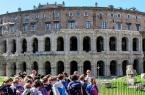
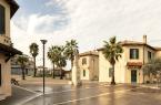
Pasear entre los preciosos restos históricos y la naturaleza prístina que rodea el Área arqueológica de los puertos imperiales de Claudio y Trajano es como viajar en el tiempo a un lugar lleno de ecos del pasado y encantos evocadores: el lugar ideal para aquellos que aman la tranquilidad y un viaje inusual pero fascinante, lejos de los destinos turísticos habituales y del caos de la ciudad.
El Puerto de Claudio
En el año 42 d.C., el emperador Claudio inició la construcción de un gran puerto marítimo al norte de la desembocadura del Tíber, dada la progresiva colmatación del puerto fluvial de Ostia.
El nuevo puerto, una vasta dársena de unas 150 hectáreas con dos muelles curvos y varios muelles de amarre, estaba dominado por un gran faro de varios pisos, que probablemente se alzaba sobre una isla artificial que actuaba como divisoria de aguas entre los accesos norte y sur del puerto, dividiéndolo en dos bocas.
El puerto de Claudio era, por tanto, una grandiosa estructura que garantizaba el abastecimiento de la ciudad, asegurando el transporte seguro de las mercancías, haciéndolas pasar desde los grandes barcos diseñados para la navegación en mar abierto hasta las embarcaciones fluviales (naves caudicariae) construidas para viajar por el Tíber hasta Roma.
La conexión entre el puerto de Claudio y el Tíber estaba asegurada por al menos dos canales artificiales, cuya imponencia se aprecia en los cimientos del muelle norte, aún visibles hoy en día a lo largo de aproximadamente un kilómetro detrás del Museo delle Navi.
En el antiguo muelle norte también se pueden identificar varias estructuras pertenecientes al puerto, como la "Capitanería", una cisterna, y varios edificios termales (el complejo Monte Giulio), que datan del siglo II d.C.
El puerto se volvió cada vez más inutilizable e inseguro debido a la sedimentación progresiva. Por ello, entre los años 100 y 112 d. C., se construyó una nueva dársena: el Puerto de Trajano.
El Puerto de Trajano
Al faro y a los muelles del puerto de Claudio, integrados en el nuevo sistema portuario, Trajano hizo añadir una dársena hexagonal de 33 hectáreas, una grandiosa obra de ingeniería que aumentó el número de puntos de amarre para los barcos. También se excavaron otros canales, como la Fosa Trajana, el actual Canal de Fiumicino, para permitir que las aguas de las crecidas fluyeran hacia el mar, liberando a Roma del azote de las inundaciones.
Entre los edificios más importantes erigidos en el puerto se encuentran los Almacenes Severianos, grandes almacenes de mercancías construidos a mediados del siglo II d.C., y el Palacio Imperial, un suntuoso edificio de estado que albergaba a viajeros de alto rango, ambos con vistas a la dársena hexagonal. Los Almacenes Trajanos, por otro lado, se desarrollaron alrededor de la Dársena, la dársena interna donde se cargaban las mercancías en pequeños barcos que navegaban por el Tíber y donde los barcos fondeaban durante los meses de invierno.
Las grandes columnas almohadilladas que todavía hoy se pueden admirar durante la visita son las famosas “colonnacce" (“columnas”) de travertino, restos de un grandioso pórtico de la época de Claudio, que Trajano reutilizó cerrando los espacios entre ellos para crear almacenes y oficinas.
En los siglos II y III, la importancia del puerto propició el establecimiento de un asentamiento permanente, que en el año 314 d. C. se convirtió oficialmente en ciudad con el nombre de Portus Romae. Sin embargo, con el paso de los siglos, debido al avance de la costa y a la cambiante morfología del terreno, se fue convirtiendo paulatinamente en pantanoso. La dársena portuaria se llenó casi por completo entre la Edad Media y la época moderna.
Hoy en día, el mar se encuentra a unos cuatro kilómetros del centro histórico, ahora enclavado entre la infraestructura del Aeropuerto Leonardo da Vinci y las carreteras modernas.
La zona arqueológica se divide actualmente entre el Parque arqueológico de Ostia Antica y la familia Sforza-Cesarini, propietaria de la cuenca de Trajano.
Foto: Parque Arqueológico de Ostia Antica
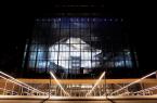
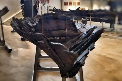
El Museo de los Barcos en Fiumicino
 Condividi
Aeropuerto Internacional Leonardo da Vinci
 Condividi
Parque Arqueológico de Ostia Antica
 Condividi
Informaciones
From Tuesday to Sunday and on holidays.
From 8.30 - 16.30 (last admission 15.30 ) from 25 October to 28 (or 29) February
From 8.30 - 17.15 (last admission 16.15) from 1st March to 31st March:
From 8.30 - 19.00 (last admission 18.00) from 1st April to 30th September
From 8.30- 18.30 (last admission 18.30) from 1st October to 24th October
Closed on Monday and December 25th.
Special openings: Monday 24 and Tuesday 25 April and Monday 1 May 2023
Special closures: Tuesday 11 April, Wednesday 26 April and Tuesday 2 May 2023
For updates and guidelines consult the official website.
Condividi
Location
Para conocer todos los servicios de accesibilidad, visite la sección Roma accesible.